Snow Has Started To Fall Around The Area
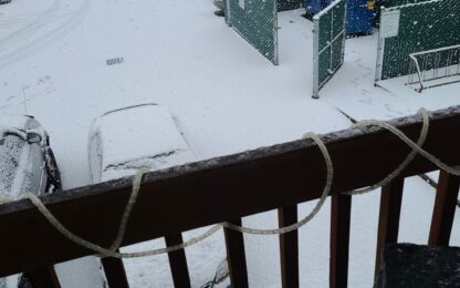
Portland, Ore. — A fresh dusting of show is showing up in Washington County Tuesday afternoon.
Already starting to stick on vehicles and parking lot. pic.twitter.com/1g1pjAICMk
— Forest Grove Fire (@ForestGroveFire) January 26, 2021
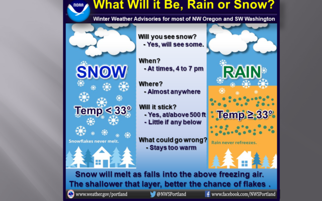
The National Weather Service says areas like Forest Grove could see 1 – 2 inches of snow by midnight.
Light snow spreading inland. So far, light accumulations for areas of Willamette Valley w of Hwy 99, but closer to Coast Range (above 300 feet) have 1-2 inches since noon today. Expect less than 1 inch in many spots, as main sticking snows stay above 500 ft. #pdxtst #orwx #wawx pic.twitter.com/qGaJnLIiuv
— NWS Portland (@NWSPortland) January 26, 2021
A Winter Weather Advisory is also in place for the Portland Metro Area:
Greater Portland Metro Area-Greater Vancouver Area-
Including the cities of Hillsboro, Portland, Wilsonville,
Oregon City, Gresham, Troutdale, Vancouver, Battle Ground,
Ridgefield, Washougal, Yacolt, and Amboy
158 PM PST Tue Jan 26 2021

...WINTER WEATHER ADVISORY REMAINS IN EFFECT UNTIL 4 AM PST
WEDNESDAY...

* WHAT...Wet snow expected. Total snow accumulations of up to
  two inches. Winds gusting as high as 35 mph.

* WHERE...In Washington, Greater Vancouver Area. In Oregon,
  Greater Portland Metro Area.

* WHEN...Until 4 AM PST Wednesday.

* IMPACTS...Roads above 500 feet may be snow covered at times.

* ADDITIONAL DETAILS...The heaviest precipitation is expected
  from early evening through midnight. Snow levels will be
  around 500 feet early this evening, but rise to 1000 feet
  overnight. Areas such as Banks and Forest Grove may see 1 to 2
  inch accumulations this evening. Less than an inch of snow
  expected in and around Portland.

PRECAUTIONARY/PREPAREDNESS ACTIONS...

Consider alternate routes, especially if traveling in areas above
500 feet and in rural eastern Clark County.

The latest road conditions for the state you are calling from can
be obtained by calling 5 1 1.


You Might Also Like