Potentially Historic Wind Storm Brings Extreme Fire Danger And Likely Power Outages Starting Monday Evening
Portland, Ore. – Avoid all burning and fires right now and be extra careful with open flame. The National Weather Service in Portland has issued a Red Flag Warning for the metro area starting Monday. Forecasters are calling for a potentially historic wind storm that is making fire conditions extremely dangerous, and some should expect to see power outages from limbs and trees possibly coming down. Forecaster Colby Newman with NWS Portland tells Fm News 101 KXL, we rarely see a wind storm like this during this part of the year, it’s something that happens once every few decades.
The metro area is expecting to see strong wind gusts up to around 50 mph, combined with warmer than normal temperatures, and hot and dry conditions- it’s a recipe for potential fire disaster. Any fire has the potential to spread rapidly beyond control once the heavy winds start Monday evening. Labor Day campers are being sent home from areas and are being told all fires are prohibited in some areas. Local power companies and state agencies are considering power black outs, shutting down electricity to some areas to prevent any fires from starting. Officials urge you not to start any fires or do any kind of burning for the next few days. Also, don’t park a hot engine on top of dry grass that can catch fire too.
Click Here For Pacific Power Outages
Click Here For Clark County PUD Outages
KXL’s Jacob Dean talked more with NWS Portland’s Colby Newman:

Red Flag Warning
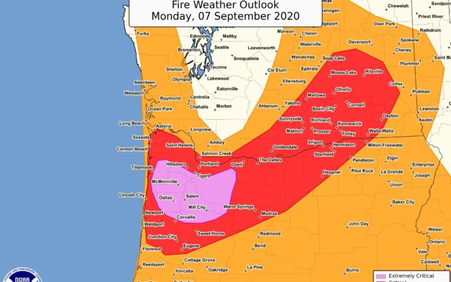
URGENT - FIRE WEATHER MESSAGE
National Weather Service Portland OR
331 PM PDT Sun Sep 6 2020

HISTORIC SEPTEMBER EAST WIND EVENT LIKELY, PEAKING MONDAY
NIGHT AND TUESDAY...

EXTREMELY DRY CONDITIONS LIKELY TUESDAY AND WEDNESDAY...

Hot, dry, and strong easterly winds are expected starting Monday
afternoon, peaking overnight Monday into Tuesday morning, then
slowly easing through Tuesday evening. These winds have the
potential to reach historic speeds for early to mid September.
Winds likely to initially reach speeds greater than 15 mph in Fire
Weather Zones 605, 607 and 660 by midday Monday but will quickly
increase in all other zones later Monday and Monday night.
Relative humidities are expected to reach critical levels
overnight and Tuesday with the influx of dry air.

Willamette Valley-Clark County Lowlands-
331 PM PDT Sun Sep 6 2020

RED FLAG WARNING REMAINS IN EFFECT FROM 11 AM MONDAY TO 8 PM
PDT WEDNESDAY FOR WIND AND LOW RELATIVE HUMIDITY FOR FIRE WEATHER
ZONES 604 AND 667...

* Affected Area...
  In Oregon...
  - Fire Weather Zone 604 Willamette Valley.

  In Washington...
  - Fire Weather Zone 667 Clark County Lowlands.

* Winds...Northeast 15 to 25 mph with gusts up to 45 mph.

* Relative Humidity...As low as 10 percent. Poor overnight
  humidity recoveries for most of the area.

* Impacts...Conditions will be favorable for rapid fire spread
  which may threaten life and property. Use extra caution with
  potential ignition sources, especially in grassy areas.
  Outdoor burning is not recommended.

PRECAUTIONARY/PREPAREDNESS ACTIONS...

A Red Flag Warning means that critical fire weather conditions
are either occurring now, or will shortly. A combination of the
above conditions can contribute to extreme fire behavior.
Wind Advisory
URGENT - WEATHER MESSAGE
National Weather Service Portland OR
102 PM PDT Sun Sep 6 2020

Greater Portland Metro Area-Greater Vancouver Area-
Including the cities of Hillsboro, Portland, Wilsonville,
Oregon City, Gresham, Troutdale, Vancouver, Battle Ground,
Ridgefield, Washougal, Yacolt, and Amboy
102 PM PDT Sun Sep 6 2020

WIND ADVISORY NOW IN EFFECT FROM 5 PM MONDAY TO 1 PM PDT
TUESDAY...

* WHAT...East winds 15 to 25 mph with gusts 40 to 55 mph
  expected.

* WHERE...In Washington, Greater Vancouver Area. In Oregon,
  Greater Portland Metro Area.

* WHEN...From 5 PM Monday to 1 PM PDT Tuesday.

* IMPACTS...Gusty winds could blow around unsecured objects.
  Some tree limbs will likely be blown down and a few power
  outages may result.

* ADDITIONAL DETAILS...Windy conditions will be most prevalent on
  the Oregon side, but strong gusts will be possible anywhere in
  the metro area. Strongest gusts will likely be in the higher
  terrain of the metro area, such as the West Hills of Portland,
  Mount Scott, and Rocky Butte.

* FIRE CONCERNS...Conditions will be favorable for rapid fire
  spread. Use extreme caution with potential ignition sources.

PRECAUTIONARY/PREPAREDNESS ACTIONS...

Use extra caution when driving, especially if operating a high
profile vehicle. Secure outdoor objects.

For more information from the National Weather Service visit
https://weather.gov/portland