Flooding Advisories In Effect Due To Heavy Rain
January 6, 2022 6:41PM PST
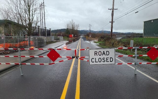
Fern Hill Road closed in Washington County
PORTLAND, Ore. — The National Weather Service has issued several flood advisories, watches and warnings for the coming days as rain pounds the Pacific Northwest.
Rainy and windy conditions are expected tonight through Friday morning as a strong frontal system pushes inland. River flooding will be the main impact, but there is also the potential for a few downed trees/power lines (especially for the coast and Coast Range). #orwx #wawx pic.twitter.com/McQqly1OoN
— NWS Portland (@NWSPortland) January 6, 2022
FLOOD ADVISORY REMAINS IN EFFECT UNTIL 4 PM PST FRIDAY...

* WHAT...Small stream flooding caused by excessive rainfall
continues.

* WHERE...Portions of northwest Oregon and southwest Washington,
including the following counties, in northwest Oregon, Benton,
Clackamas, Clatsop, Columbia, Lane, Lincoln, Marion, Multnomah,
Polk, Tillamook, Washington and Yamhill. In southwest Washington,
Clark, Cowlitz, Pacific and Wahkiakum.

* WHEN...Until 400 PM PST Friday.

* IMPACTS...Flooding of small streams and creeks, as well as areas
with poor drainage. Expect ponding of water in urban areas.

* ADDITIONAL DETAILS...
- At 619 PM PST, Snowmelt and/or periods of moderate to heavy
rain will result in small stream flooding and flooding in
areas of poor drainage overnight into Friday.
- Additional rainfall amounts of a quarter to three quarters of
an inch in the Willamette Valley and 1 to 3 inches in the
Coast Range and Willapa Hills are still expected.
FLOOD WATCH REMAINS IN EFFECT THROUGH FRIDAY AFTERNOON...

* WHAT...Flooding caused by rain and snowmelt continues to be
possible.

* WHERE...Portions of northwest Oregon and southwest Washington,
including the following areas, in northwest Oregon, Cascade
Foothills in Lane County, Cascades in Lane County, Central Coast
Range of Western Oregon, Central Columbia River Gorge, Central
Oregon Coast, Central Willamette Valley, Coast Range of Northwest
Oregon, Greater Portland Metro Area, Lower Columbia, North Oregon
Coast, Northern Oregon Cascade Foothills, Northern Oregon
Cascades, South Willamette Valley and Upper Hood River Valley. In
southwest Washington, Central Columbia River Gorge, Greater
Vancouver Area, I-5 Corridor in Cowlitz County, South Washington
Cascade Foothills, South Washington Cascades, South Washington
Coast, Western Columbia River Gorge and Willapa Hills.

* WHEN...Through Friday afternoon.

* IMPACTS...Excessive runoff may result in flooding of rivers,
creeks, streams, and other low-lying and flood-prone locations.
Creeks and streams may rise out of their banks.

* ADDITIONAL DETAILS...
- Heavy rain combined with snow melt will lead to areas of
flooding. The most severe flooding will likely occur north of
a line extending between Tillamook to Portland.
FLOOD WARNING REMAINS IN EFFECT FROM FRIDAY EVENING THROUGH
SUNDAY EVENING...

* WHAT...Minor flooding is forecast.

* WHERE...Pudding River at Aurora.

* WHEN...From late Friday to late Sunday evening.

* IMPACTS...Above 22.0 feet, expect minor flooding of low-lying
agricultural lands and access roads along the river.

* ADDITIONAL DETAILS...
- At 6:30 PM PST Thursday the stage was 20.2 feet.
- Forecast...The river is expected to rise above flood stage
late Friday or early Saturday. The river is expected to crest
near 22.6 ft late Saturday or early Sunday.
- Flood stage is 22.0 feet.
More about: